| You’re invited! Draper Landing to Berry Hill Float June 4  Join in DRBA’s seven-mile float on the Dan River from Eden’s Draper Landing Access to Berry Hill Bridge on June 4, coordinated by Will Truslow, DRBA’s past president. Meet at 10:00 a.m. at the access’s graveled parking lot beside the NC 700 Bridge to set the shuttle (GPS 36.4987, -79.6814). Three Rivers Outfitters of Eden, 336-627-6215 or www.3-R-O.com, will offer boat rentals and shuttle for the float, which will end on private property with the owner’s permission. In this river trip of Class I water, participants will navigate at least seven ledges and shoals with long-standing historic names found on old maps. Six of these have been made easier to navigate by structures such as sluice walls built in the nineteenth century by the Roanoke Navigation Company (founded 1812), a joint effort of Virginia and North Carolina, and by the US Army Corps of Engineers. The sluice walls concentrate the river’s water at shallow ledges, creating a narrow channel deep enough to float long, narrow batteaux, the commercial “semi-trailers” of early river travel. Nearly a century before the river was improved for navigation, in 1728 a survey team led by Virginia’s William Byrd determined the “dividing line” between North Carolina and Virginia. Byrd named the Dan River for the river in northern Israel and gave names that still survive to many of the river’s tributaries. One was Cascade Creek, which enters from river left about halfway through the trip, so called “by reason of the multitude of waterfalls that are in it” some distance before it reaches the Dan. Devil’s Jump Shoal, just downstream from Cascade Creek, is named for impressive mid-river rocks. On river right less than a mile downstream from Devil’s Jump is the confluence of the Dan with Tanyard Creek, named for the tannery owned by John Morehead, father of North Carolina Governor John Motley Morehead, who grew up nearby. Between two old sluice walls of Tanyard Shoal, separated by nearly a half-mile of the Dan’s flow, is a place called on an 1823 survey “The Wreck,” according to William E. Trout III, author of the Dan River Atlas. “Why?” he asks, inviting future river mappers to solve the mystery. Other examples of intriguing nineteenth-century labels are Beasley’s Gallows Shoal Sluice and the well-preserved Hairston’s Fish Trap Sluice, likely modified from an Amerindian fish weir of 1000 years ago. The trip is part of the series of over 100 First Saturday Outings that have been offered by DRBA almost from its inception. Other interesting facts about the geology, history, and culture of this section of the river are found in Maps 42 – 45 of “An Insider’s Guide to the Dan River in North Carolina and Virginia,” available at www.danriver.org . | ||
Participants in the outing are asked to provide boat, life jacket, lunch and water, to dress in layers of artificial (quick-drying) fabric and to sign a waiver. | ||
Directions: To reach Draper Landing Access (GPS 36.4987, -79.6814) from the north or west, take NC 14 to NC 700 East. Travel on NC 700 about 4 miles through Eden to the bridge over the Dan River. After crossing the bridge, go 0.1 mile and turn left into the gravel driveway to the access. From the south take US 29 North, turning left (west) on NC 700. Just past Quesinberry Road, turn right into the gravel driveway to the access beside the NC 700 Bridge over the Dan. From the east take US 29 South, turning right (west) on NC 700, and proceed as described above. | ||
More information: For trip information, contact trip coordinator Will Truslow, 336-547-1903, willtruslow@hotmail.com | ||
|
Thursday, May 19, 2011

Tuesday, April 12, 2011
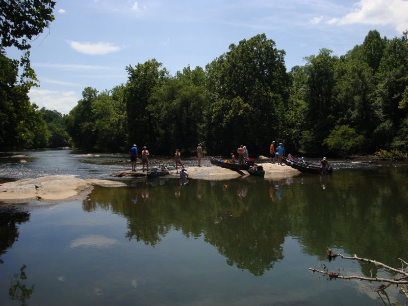
DRBA First Saturday Outing for May
| DRBA Paddles the Dan in Stokes County |
| DRBA’s May 7 First Saturday Outing will be a 5-mile paddle trip on the Dan River in Stokes County from Snow Creek Access to Hemlock Golf Course Access coordinated by Will Truslow.  Meet at 10:00 a.m. at the Snow Creek Access, about 200 yards west of Dodgetown Road Bridge on Pitzer Road (GPS 36.4026, -80.1404), to unload boats and gear and set the shuttle. For boat rentals and shuttle, contact Three Rivers Outfitters, 336-627-6215 or 276-340-3983, www.3-r-o.com, or Dan River Company, 336-593-2628, www.danrivercompany.com. History and legend abound on this section of the river, which is characterized by high bluffs forested with hardwoods and stands of stately hemlock trees. Just upstream of the put-in is the frame of the Pitzer Steel Truss Bridge, dating from 1918. About half a mile below Snow Creek is Thompson’s Fish Dam, which has remnants of a rare wooden slat trap. According to “An Insider’s Guide to the Dan River,” a “heavy timber frame, about eight feet square, formed a grid of slats” to trap fish channeled into the trap by a vee-shaped low rock wall. At least two branches of the Great Wagon Road forded the river at shoals on this section, and caves are said to have been used by Confederate draft dodgers. Rock formations and uncommon Carolina hemlock stands have received recognition as the Dan River Cliffs natural heritage area. According to Truslow, “This section of the Dan has the last of the really high bluffs before the river winds on into the Piedmont. Some are about 150 feet high.” The most spectacular is Davis Bluff, a dramatic rock face on river left where huge boulders lie in the water at the base of the cliff. Legend says that a member of the Davis family fell to his death from the road on top. To this day, the cliff is known as Mount Horrible. The Dan River in this section is rated mostly as Class 1, but the remains of a former Duke Power dam, dynamited in 1975, create a sometimes challenging Class 2 rapid. Fortunately, it is located within sight of the take-out ramp at Hemlock Golf Course. Meet at 10:00 at the Snow Creek Access on Pitzer Road. Arrange to supply boat, paddles, life jackets, water and lunch; wear water-shedding artificial fabric or wool (not cotton, and certainly not blue jeans); and provide a back-up change of clothing. All participants will be asked to sign a waiver. Directions: At the intersection of NC 8 and NC 89 about 3 miles south of Danbury, NC, turn northeast onto Dodgetown Road. Drive about 4 miles and cross the Dan River. Immediately turn left onto Pitzer Road. Snow Creek Access is on the left in about 200 yards. Driving south from Virginia on US 220, turn west on NC 770 to Sandy Ridge. Turn south on NC 704 to Prestonville. Turn south on NC 772 toDodgetown. Turn right onto Dodgetown Road and drive about 4 miles. Just before crossing the Dan River, turn right onto Pitzer Road. Snow Creek Access is on the left in about 200 yards. |
Thursday, March 24, 2011
Back to the River !
|


Tuesday, November 2, 2010
Fall Paddle and Hike on the Dan
Tuesday, August 31, 2010
Marrowbone Creek to Mitchel Bridge float on 9/4/10
On September 4 DRBA will celebrate Labor Day weekend with a float on the most popular section of the Smith River-Marrowbone Creek Access to Mitchell Bridge Access in Henry County, VA. Meeting at 10:00 a. m. at the Richard P. Gravely, Jr. Nature Preserve, 2525 Eggleston Falls Road in Ridgeway, Virginia (36.611067, -79.817712), the group will launch canoes and kayaks at the nearby access point.

The 3.5-mile "blueway" Smith River Trails section, rated Class 1, is suitable for novice paddlers. Trip coordinator is Wayne Kirkpatrick, DRBA President, aided by other DRBA members who frequent this section of the river.
For the first half mile of the trip, the river flows alongside the Gravely Nature Preserve's high bluffs where paddlers can glimpse the Rhododendron Trail. As the name implies, the path winds through a rhododendron thicket as it hugs the river's edge.
About a mile farther on, Leatherwood Creek enters from river left. Paddlers often enter the wide mouth of the creek and take a leisurely side trip up the shaded stream to observe woodland wildflowers and birds. Early American patriot Patrick Henry, for whom both Patrick and Henry counties are named, lived on a large plantation near the headwaters of Leatherwood Creek from 1779 - 1786.

Just below the mouth of Leatherwood Creek is a broad rounded boulder in the middle of the river. Known as "Lunch Rock," it makes "a perfect spot to stop for a break," according to "An Insider's Guide to the Smith River," available at www.danriver.org .
Henry County, in partnership with DRBA, has made the Smith River accessible to the public over the past three years by building public access points at eight new sites along the river, including the Marrowbone Creek Access, which opened in 2007, and Mitchell Bridge Access, built in 2009.
Participants are invited to linger after the outing to enjoy the Gravely Nature Preserve, part of the county's "greenway" Smith River Trail system, which was dedicated in April, 2008. Developed by DRBA and Henry County, with funding from The Harvest Foundation, the 75-acre preserve features two miles of interpretive trails. Historic features include early twentieth-century tobacco barns and the Burgess Family cemetery, reminders of former owners of the property.
Industrialist, civic leader, and archaeologist Richard P. Gravely, Jr. owned the property in the late twentieth century and left instructions for its preservation as a wildlife and nature conservancy. The preserve now hosts frequent educational and recreational events for all ages, including day camps, fitness walks, historic presentations, workshops, after-school programs, and geo-caching.
Participants in the outing are asked to bring boat and paddles, life jackets, lunch and water, to dress in layers of artificial (quick-drying) fabric and to sign a waiver.
Boats may be rented from Three Rivers Outfitters, 336-627-6215
www.3-R-O.com
or
Smith River Adventure Outfitters, 276-252-0701
http://www.smithriveradventureoutfitters.com/
Directions: To reach the Gravely Nature Preserve from US 220 south of Martinsville, turn east at a traffic light onto Old Sand Road. Cross the US 58 overpass and immediately turn left onto Eggleston Falls Road. Travel about two miles to the preserve, which is on the left, across from the foot of Old Mill Road.
| |
Tuesday, July 13, 2010
The new canoe access ramp at Soulutia (CPFilms) is nearly completeThis is going to be one of our nicer access points and it’s like a mini park complete with trail and easy access.

The ramp is located off The Great Road in Stanleytown, strategically situated between the upstream access at Bassett and the next downstream access at Fieldale.


An extremely easy entry into the water, the ramp creates a nice access at low water and a good eddy for times of full generation. A picnic table at the access is a great place to have lunch or walk the trail downstream to another quiet location complete with picnic table and view of the river.

Saturday, July 10, 2010
Dan River Sojourn 2011
Good friends, great stories, fantastic history and 22 miles
of the Beautiful Dan River!
of the Beautiful Dan River!
Be part of the journey, the inaugural
Dan River Sojourn 2011

Join us for two days of paddling, two nights of camping -- the first of an annual event journeying down the Dan River!
Come for a day, come for a weekend. . . Great food and music each night
If you can't paddle, sign up to join us on the river for dinner!
May 20 -- 22, 2011
Additional information available online at
Don't delay! Do it today!

This 22-mile trip takes you through a Triassic basin where history is written in and on the landscape. From the days of the dinosaurs to Native Americans to our own imprint shown in nineteenth century commercial navigation, you will see and touch it all during this two-day adventure.
Assemble at Lindsay Bridge in Madison, NC by 5:00 pm on Friday, July 16, to unload camping and paddling gear. Shuttle to Settles Bridge and/or Eden is at 6:00 pm. Anticipated return to the Lindsey Bridge campsite is 7:00 pm. Each day's paddle adventure will begin at 9:00 am and conclude by 5:00 pm. Enjoy special programs highlighting the history of the Dan River region and related topics.

Limited to 100 participants, so reserve your spot early!
The Sojourn's trail includes of the nation's best-preserved nineteenth-century batteau navigation systems used to channel commercial traffic into backcountry North Carolina. Click on maps 57 through 47 of the Dan River Guide, Key Map 2 to see the trail. Each map highlights important navigation tips and details of that section of the river along with photos, history, interesting facts and more.
You can also order your own waterproof, travel-size copy of An Insiders Guide to the Dan River Basin in North Carolina and Viginia.
Two Payment Options
* Mail a check along with your completed registration form or
* Pay online (buttons below link to Pay Pal interface-SEE NOTE BELOW!)
NOTE: To make sure we understand WHO the participant(s) is/are, please click on the Message to Merchant option in Pay Pal and include ALL the name(s) of your PARTICPANT/paddlers, since they may be different than the name of the payer on Pay Pal.
Pricing (per person) (If you are paying for more than one person please make sure you adjust the shopping cart quantities.)
$25.00 – Friday: Evening meal and overnight camping only; does not include any meals/activities on next day.
$60.00 – Saturday: Three meals, programs, gear handling, overnight camping, T-shirt & shuttle
$60.00 – Sunday: Two meals, program, gear handling, T-shirt & shuttle
Package deal $130 – Full trip, camping two nights, six meals, programs, gear handling, T-shirt & shuttle
$65.00 paddle through for children 8 - 12 attending with a full fee adult guardian
Guest meals are $10.00 each for breakfast & lunch; $20.00 dinner
(Don't forget to adjust the shopping cart quantities to equal all meals requested)
Breakfast Guest Meal $10.00
Lunch Guest Meal $10.00
Dinner Guest Meal $20.00
Dan River Sojourn 2010 T-shirts featuring the colorful design shown at top of page are provided as part of the Saturday, Sunday and Package deals. Others may buy the T-shirts at the event.
Read the Sojourn 2010 liability waiver.
Call Wayne Kirkpatrick at 276.694.4449 begin_of_the_skype_highlighting 276.694.4449 end_of_the_skype_highlighting
or email
danriversojourn@gmail.com
for more information.
Reserve your place on this first-time adventure TODAY!
Subscribe to:
Comments (Atom)