Fall is the perfect time to be on the riverGet out there and enjoy the scenery and the cool weather
For now, enjoy this short video from Andy and Barbara Parker
A paddle and a hike at Hanging Rock
Tuesday, November 2, 2010
Tuesday, August 31, 2010
Marrowbone Creek to Mitchel Bridge float on 9/4/10
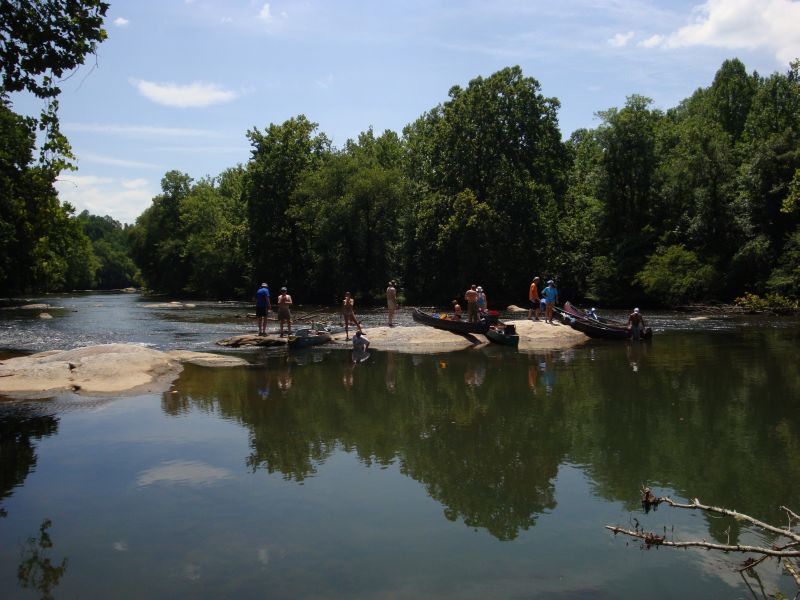
On September 4 DRBA will celebrate Labor Day weekend with a float on the most popular section of the Smith River-Marrowbone Creek Access to Mitchell Bridge Access in Henry County, VA. Meeting at 10:00 a. m. at the Richard P. Gravely, Jr. Nature Preserve, 2525 Eggleston Falls Road in Ridgeway, Virginia (36.611067, -79.817712), the group will launch canoes and kayaks at the nearby access point.

The 3.5-mile "blueway" Smith River Trails section, rated Class 1, is suitable for novice paddlers. Trip coordinator is Wayne Kirkpatrick, DRBA President, aided by other DRBA members who frequent this section of the river.
For the first half mile of the trip, the river flows alongside the Gravely Nature Preserve's high bluffs where paddlers can glimpse the Rhododendron Trail. As the name implies, the path winds through a rhododendron thicket as it hugs the river's edge.
About a mile farther on, Leatherwood Creek enters from river left. Paddlers often enter the wide mouth of the creek and take a leisurely side trip up the shaded stream to observe woodland wildflowers and birds. Early American patriot Patrick Henry, for whom both Patrick and Henry counties are named, lived on a large plantation near the headwaters of Leatherwood Creek from 1779 - 1786.

Just below the mouth of Leatherwood Creek is a broad rounded boulder in the middle of the river. Known as "Lunch Rock," it makes "a perfect spot to stop for a break," according to "An Insider's Guide to the Smith River," available at www.danriver.org .
Henry County, in partnership with DRBA, has made the Smith River accessible to the public over the past three years by building public access points at eight new sites along the river, including the Marrowbone Creek Access, which opened in 2007, and Mitchell Bridge Access, built in 2009.
Participants are invited to linger after the outing to enjoy the Gravely Nature Preserve, part of the county's "greenway" Smith River Trail system, which was dedicated in April, 2008. Developed by DRBA and Henry County, with funding from The Harvest Foundation, the 75-acre preserve features two miles of interpretive trails. Historic features include early twentieth-century tobacco barns and the Burgess Family cemetery, reminders of former owners of the property.
Industrialist, civic leader, and archaeologist Richard P. Gravely, Jr. owned the property in the late twentieth century and left instructions for its preservation as a wildlife and nature conservancy. The preserve now hosts frequent educational and recreational events for all ages, including day camps, fitness walks, historic presentations, workshops, after-school programs, and geo-caching.
Participants in the outing are asked to bring boat and paddles, life jackets, lunch and water, to dress in layers of artificial (quick-drying) fabric and to sign a waiver.
Boats may be rented from Three Rivers Outfitters, 336-627-6215
www.3-R-O.com
or
Smith River Adventure Outfitters, 276-252-0701
http://www.smithriveradventureoutfitters.com/
Directions: To reach the Gravely Nature Preserve from US 220 south of Martinsville, turn east at a traffic light onto Old Sand Road. Cross the US 58 overpass and immediately turn left onto Eggleston Falls Road. Travel about two miles to the preserve, which is on the left, across from the foot of Old Mill Road.
| |
Tuesday, July 13, 2010
The new canoe access ramp at Soulutia (CPFilms) is nearly completeThis is going to be one of our nicer access points and it’s like a mini park complete with trail and easy access.

The ramp is located off The Great Road in Stanleytown, strategically situated between the upstream access at Bassett and the next downstream access at Fieldale.


An extremely easy entry into the water, the ramp creates a nice access at low water and a good eddy for times of full generation. A picnic table at the access is a great place to have lunch or walk the trail downstream to another quiet location complete with picnic table and view of the river.

Saturday, July 10, 2010
Dan River Sojourn 2011
Good friends, great stories, fantastic history and 22 miles
of the Beautiful Dan River!
of the Beautiful Dan River!
Be part of the journey, the inaugural
Dan River Sojourn 2011

Join us for two days of paddling, two nights of camping -- the first of an annual event journeying down the Dan River!
Come for a day, come for a weekend. . . Great food and music each night
If you can't paddle, sign up to join us on the river for dinner!
May 20 -- 22, 2011
Additional information available online at
Don't delay! Do it today!

This 22-mile trip takes you through a Triassic basin where history is written in and on the landscape. From the days of the dinosaurs to Native Americans to our own imprint shown in nineteenth century commercial navigation, you will see and touch it all during this two-day adventure.
Assemble at Lindsay Bridge in Madison, NC by 5:00 pm on Friday, July 16, to unload camping and paddling gear. Shuttle to Settles Bridge and/or Eden is at 6:00 pm. Anticipated return to the Lindsey Bridge campsite is 7:00 pm. Each day's paddle adventure will begin at 9:00 am and conclude by 5:00 pm. Enjoy special programs highlighting the history of the Dan River region and related topics.

Limited to 100 participants, so reserve your spot early!
The Sojourn's trail includes of the nation's best-preserved nineteenth-century batteau navigation systems used to channel commercial traffic into backcountry North Carolina. Click on maps 57 through 47 of the Dan River Guide, Key Map 2 to see the trail. Each map highlights important navigation tips and details of that section of the river along with photos, history, interesting facts and more.
You can also order your own waterproof, travel-size copy of An Insiders Guide to the Dan River Basin in North Carolina and Viginia.
Two Payment Options
* Mail a check along with your completed registration form or
* Pay online (buttons below link to Pay Pal interface-SEE NOTE BELOW!)
NOTE: To make sure we understand WHO the participant(s) is/are, please click on the Message to Merchant option in Pay Pal and include ALL the name(s) of your PARTICPANT/paddlers, since they may be different than the name of the payer on Pay Pal.
Pricing (per person) (If you are paying for more than one person please make sure you adjust the shopping cart quantities.)
$25.00 – Friday: Evening meal and overnight camping only; does not include any meals/activities on next day.
$60.00 – Saturday: Three meals, programs, gear handling, overnight camping, T-shirt & shuttle
$60.00 – Sunday: Two meals, program, gear handling, T-shirt & shuttle
Package deal $130 – Full trip, camping two nights, six meals, programs, gear handling, T-shirt & shuttle
$65.00 paddle through for children 8 - 12 attending with a full fee adult guardian
Guest meals are $10.00 each for breakfast & lunch; $20.00 dinner
(Don't forget to adjust the shopping cart quantities to equal all meals requested)
Breakfast Guest Meal $10.00
Lunch Guest Meal $10.00
Dinner Guest Meal $20.00
Dan River Sojourn 2010 T-shirts featuring the colorful design shown at top of page are provided as part of the Saturday, Sunday and Package deals. Others may buy the T-shirts at the event.
Read the Sojourn 2010 liability waiver.
Call Wayne Kirkpatrick at 276.694.4449 begin_of_the_skype_highlighting 276.694.4449 end_of_the_skype_highlighting
or email
danriversojourn@gmail.com
for more information.
Reserve your place on this first-time adventure TODAY!
Wednesday, June 30, 2010
Paddle Lake Talbott on Saturday
DRBA to Paddle Lake Talbott near Meadows of Dan 

Out-and-back paddle on Lake Talbott near Meadows of Dan, VA Meet at 10:00 a.m. at Poor Farmers Market, 2616 Jeb Stuart Highway, Meadows of Dan, VA. GPS: 36.73541, -80.40978. Dress in layers of synthetic fabric, and bring boat, paddles, life jackets,lunch and water. Free and open to the public.
Contact: Charlie Williams
Phone: 336-337-8843
Email: chawilliams59@yahoo.com
Need a boat ? Contact one of our local outfitters:

(336)627-6215

(276)252-0701
Wednesday, May 19, 2010
Charlie Poole Festival and Float
(Eden, NC) – The folks who come to the Fifteenth Anniversary Charlie Poole Music Festival, June 11-13, will have a surprise extra treat all ready for them. On Saturday morning they will have the opportunity to enjoy a float down a stretch of the beautiful unspoiled Smith and Dan Rivers, and still not miss any of the festival.
This special outing, beginning at 9 AM Saturday morning with transport from the Fairgrounds, has been arranged through the Dan River Basin Association. The Director, Katherine Mull, gives the following description of the event as planned:
Internationally renowned banjo musician Charlie Poole worked here at Spray Cotton Mills. In July 1925 Poole and his North Carolina Ramblers made their first recording with Columbia Records. Their record was a smash hit and sold an unheard of number, more than 100,000 copies.
Also nearby is the historic 1898 Nantucket Mill. Piedmont Folk Legacies and the National Banjo Initiative envision a new life for the mill as a National Banjo Center, museum, recording studio and performance venue.
After putting on the river at Spray Cotton Mills, paddlers will float under Island Ford Bridge near Spray Circle and past the new Island Ford Landing at Eden’s Smith River Greenway. About a mile downstream, after passing under the Kings Highway Bridge, paddlers will come upon a large rock formation on river left known as Bear Slide, a state Natural Heritage Area recognized for rare communities of wild flowers.
Paddlers can expect to see June wildflowers, water fowl and perhaps even Eden’s mascot, a river otter.
Past Bear Slide, where the Smith joins the Dan River, paddlers will turn upstream a short distance to view the impressive remains of the 1852 Leaksville Toll Bridge. After floating down to the nationally famous arched Mebane Bridge, paddlers will take out at the NC Wildlife Access on the Dan River where all will be shuttled back to the Charlie Poole Festival in time for lunch at the fairgrounds.
The Saturday morning expedition includes the boat rental and guide, transport to and from the Fairgrounds, a light breakfast, refreshments on the trip, and a voucher for lunch, all for $50 inclusive of the whole festival, Friday evening through Sunday morning. Space will be limited, so sign up early, on line, or just send your check to P.O. Box 867, Eden, NC 27289.
As usual, admission to the festival only is $15 for Friday evening or the Saturday afternoon and evening competition, or $25 for the whole weekend. Sunday morning activities are to be announced.
Basic camping is available, with bathrooms and showers, at a charge of $10 per night, $20 maximum, and campers will be welcome any time during the week preceding the festival. A group of 6 family and friends can get a weekend pass on line for $100, a substantial saving. Festival tickets and tickets for the River Ramble will be available on line, the latter to be limited in number– first come, first served.
A “Little Ramblers” children’s area, sponsored by Sheetz, will be another new addition. Food and other vendors will be on-site for the festival. Schedules and other information will be posted soon at www.charlie-poole.com. For further information call 336-623-1043.
This project receives support from the Rockingham County Arts Council and the NC Arts Council, an agency of the NC Department of Cultural Resources.
This special outing, beginning at 9 AM Saturday morning with transport from the Fairgrounds, has been arranged through the Dan River Basin Association. The Director, Katherine Mull, gives the following description of the event as planned:
Charlie Poole River Ramble
The Charlie Poole River Ramble, a leisurely two hour float, will be guided by Three Rivers Outfitters. The trip begins on the scenic Smith River, near the historic 1892 Spray Mercantile Building where paddlers will hear the stories of this once-thriving textile town.Internationally renowned banjo musician Charlie Poole worked here at Spray Cotton Mills. In July 1925 Poole and his North Carolina Ramblers made their first recording with Columbia Records. Their record was a smash hit and sold an unheard of number, more than 100,000 copies.
Also nearby is the historic 1898 Nantucket Mill. Piedmont Folk Legacies and the National Banjo Initiative envision a new life for the mill as a National Banjo Center, museum, recording studio and performance venue.
After putting on the river at Spray Cotton Mills, paddlers will float under Island Ford Bridge near Spray Circle and past the new Island Ford Landing at Eden’s Smith River Greenway. About a mile downstream, after passing under the Kings Highway Bridge, paddlers will come upon a large rock formation on river left known as Bear Slide, a state Natural Heritage Area recognized for rare communities of wild flowers.
Paddlers can expect to see June wildflowers, water fowl and perhaps even Eden’s mascot, a river otter.
Past Bear Slide, where the Smith joins the Dan River, paddlers will turn upstream a short distance to view the impressive remains of the 1852 Leaksville Toll Bridge. After floating down to the nationally famous arched Mebane Bridge, paddlers will take out at the NC Wildlife Access on the Dan River where all will be shuttled back to the Charlie Poole Festival in time for lunch at the fairgrounds.
The Saturday morning expedition includes the boat rental and guide, transport to and from the Fairgrounds, a light breakfast, refreshments on the trip, and a voucher for lunch, all for $50 inclusive of the whole festival, Friday evening through Sunday morning. Space will be limited, so sign up early, on line, or just send your check to P.O. Box 867, Eden, NC 27289.
As usual, admission to the festival only is $15 for Friday evening or the Saturday afternoon and evening competition, or $25 for the whole weekend. Sunday morning activities are to be announced.
Basic camping is available, with bathrooms and showers, at a charge of $10 per night, $20 maximum, and campers will be welcome any time during the week preceding the festival. A group of 6 family and friends can get a weekend pass on line for $100, a substantial saving. Festival tickets and tickets for the River Ramble will be available on line, the latter to be limited in number– first come, first served.
A “Little Ramblers” children’s area, sponsored by Sheetz, will be another new addition. Food and other vendors will be on-site for the festival. Schedules and other information will be posted soon at www.charlie-poole.com. For further information call 336-623-1043.
This project receives support from the Rockingham County Arts Council and the NC Arts Council, an agency of the NC Department of Cultural Resources.
Tuesday, April 13, 2010
Seeking Volunteer Coordinator
____________________________________________
Do you have a passion for preserving and protecting local rivers, natural areas and cultural landscapes for future generations? The Dan River Basin Association (DRBA) is seeking a dedicated volunteer to fill our Volunteer Coordinator position. This position will allow the right candidate to make a significant difference across the region.


Do you have a passion for preserving and protecting local rivers, natural areas and cultural landscapes for future generations? The Dan River Basin Association (DRBA) is seeking a dedicated volunteer to fill our Volunteer Coordinator position. This position will allow the right candidate to make a significant difference across the region.

The Volunteer Coordinator will work with DRBA staff to enlist volunteers and coordinate the activities of other community volunteers across the Dan River region in NC and Virginia. While this is a volunteer position, DRBA is offering a monthly stipend to help compensate for the volunteer’s mileage, cell phone use, and meal expenses. The Volunteer Coordinator will have access to office space, including a computer and internet. This highly visible position is ideal for someone who enjoys working as part of a team and who seeks to establish a track record, build a network, and make a measurable difference for the Dan River region.
Specific duties include working with the DRBA team to:
Coordinate recruitment, screening and training of DRBA volunteers;
Provide encouragement, feedback and support to volunteers;
Track volunteer hours and periodically evaluate volunteer performance;
Conduct regularly scheduled meetings with volunteers to foster teamwork;
Schedule volunteers for activities such as festivals, stream monitoring, children’s environmental education programs, and more;
Help coordinate and otherwise assist in media relations, including press releases.

Qualifications include:
Enjoy working with and motivating people of all ages
Interest in DRBA’s work in recreation, education and stewardship
Demonstrated leadership skills, enthusiasm and ability to inspire others;
Positive attitude and successful experience in working with people of all demographic groups;
Demonstrated team player, with commitment to the mission and values of the Dan River Basin Association;
Experience in Microsoft Office, Excel, internet and e-mail;
Valid driver’s license, ability to travel and volunteer during evenings and weekends as needed.
To Apply
Please e-mail letter of interest, three references and resume to drba.nc@danriver.org.
Saturday, April 3, 2010
DRBA's Recreational Gear Swap
| April 10, 2010 | |||||
DRBA's Recreational Gear Swap | |||||
| Need some more room in your garage for more gear ? Got extra room for gear and you need to fill it up ? Then come on out this Saturday, April 10th to the Dan River Basin Associations 2nd annual gear swap and get prepped for the season. This years event will be held at from 10 am...till the gear is gone, at the Indian Heritage RV Park & Campground (Tensbury Drive. Martinsville) This is the location of the South Martinsville canoe access on the Smith River just below Martinsville Dam. Bring your outdoor gear,canoes, kayaks, bicycles, camping gear, fishing supplies, and more! Buy, sell , trade. Admission is free. The Gear Swap is a great way to pick up used gear for a bargain or sell gear you are ready to part with. Meet other paddlers, cyclists, and outdoor enthusiasts. Come meet new friends, trade stories, and get a good deal on used equipment at DRBA’s Gear Swap! For more information contact the Dan River Basin Association at 276-634-2592 or bwilliams@danriver.org |
Thursday, March 25, 2010
Dick and Wille Passage Groundbreaking
Come out and celebrate with the Henry County Administration staff, DRBA representatives and Congressman Rick Boucher for groundbreaking on Martinsville / Henry County's latest trail,
the "Dick and Willie Passage."
 The event will occur Wednesday, March 31, at 2 p.m. near the former Martinsville-Henry County Rescue Squad building on Hooker Street in the City of Martinsville. We will park there and take a short walk onto the trail. Congressman Rick Boucher will be the keynote speaker.


the "Dick and Willie Passage."


Monday, March 8, 2010
Friends Begin Clean-up of Fieldale Trail
The “Friends of the Fieldale Trail” took to the trail on
The Fieldale Trail sustained some damage due to high water which caused mud deposition in low lying areas, debris accumulation and some split rail fence just plain disappearing downstream!

The heavy snowfall of the last two months has kept the trail blanketed and wet so repair work had to be postponed. The high water brought all manner of debris to the trial from sticks, lumber, plastic and assorted trash and lots of mud.
The recent warming trend has melted the snow and allowed the mud deposited by the floods to dry out a bit and so the trail can now be accessed for some initial clean-up work. Saturday and Sunday saw large crowds of people out on the trail, desperate for some outdoor activity after all this cold weather which has created an almost permanent state of cabin fever in our region. Walkers, bikers, and fisherman were out in force on this
The Friends of the Fieldale Trail Group (FFT ) had an impromptu Sunday clean-up and ended up removing a truck load of trash, approx. 12 bags and numerous other articles from the trail and along the river bank. They removed limbs and sticks; and gathered some fencing into piles. A big thank you to Tracy Kennett for gathering most of the fencing that had been strewn along the trail. They also reinstalled fencing along parts of the trail.


They also had several people provide them with phone numbers to call for volunteers when they have the next work day

Back row from left to right: Tracy Kennett, Tommy Wyatt, Cecil Holt, Joan Ragland, Frances Holt, Paula Wyatt
A big huge thank you to all Adopt-a-Trail Volunteers and special thank you to the
Friends of the Fieldale Trail, you guys rock !
Wednesday, February 24, 2010
Rivers and Bugs --oh my!
Everyone is invited attend the first “Rivers and Bugs Summit” on March 13 at Moral Hill Baptist Church in Axton, Virginia (just barely east of Martinsville city limits.) The $5 registration includes: light breakfast, a catered lunch by Governor, Gwendolyn & Christine Catering, and free raffle tickets for prizes such as fishing gear, a fly-fishing lesson with Brian Williams, and DRBA canvas tote bag filled with goodies.
There is something for everyone at the summit! Speakers and session leaders include: a panel discussion with a diverse group of local church and temple leaders who are spearheading various faith-based responses to environmental issues. The panel will be moderated by Linda Drage, President, Friends of Philpott.
Minnie Moore, an educator in Patrick County, will lead a session on her work with school children and organic gardening. She started an organic garden on four blighted city lots in St. Louis during her decades-long tenure at an inner city school. Most recently, she established an organic garden with students at Patrick Springs Elementary School.
Jenny Hochstein, Director of the Halifax Improvement Council and co-owner of Pick-A-Pine, will illustrate the sustainable practices she employs on her Christmas tree farm. She will discuss the challenges and opportunities to expand sustainable living practices in Southern Virginia that reduce costs and protect water quality and wildlife habitat.
Lynn Pritchett, Master Naturalist, will introduce participants to the fundamentals of the Global Positioning Systems. This is a great session for anyone who has been curious about how GPS works, what it can do for you, and how to use it—but have been too afraid to ask.
Mary Lawson, Biologist for the U.S. Army Corps of Engineers, will discuss Aldo Leopold’s moral and philosophical reasons for a harmonious relationship with the natural world and the U.S. Army Corps of Engineers’ changing attitudes toward environmental stewardship.
Wayne Kirkpatrick, DRBA President is known across the basin for his famous “Tub O’ Bugs” exhibit that introduces people of all ages to the wonders of the macro-invertebrate life in the creeks. For the first time, Wayne is leading a session on how to build your own Tub O‘Bugs for your festivals, classrooms, library programs—anywhere you want to thrill people with hands on experience with the bug life that sustains our river ecology.
Marty Bullins, Master Naturalist, will demonstrate his unique "Recycle Derby game—how he build it and how he educates watershed dwellers (that‘s all of us) on the what, when and how of recycling.
Jenny Edwards, DRBA staff, will demonstrate the “Bottle Bloom” project that engages youth in learning about watersheds and the environmental impact of litter by creating art from recycled plastic bottles. To date, more than 250 children have contributed to the bottle bloom project.
The Rivers and Bugs Summit begins at 10:00 a.m. and concludes at 2:00 p.m. on March 13 at Moral Hill Baptist Church at 50 Moral Hill Drive in Axton, Virginia. In order to give all the participants a high quality experience and a chance to fully engage in the sessions, registration is limited. “We encourage anyone interested in environmental education or healthy rivers to come out,” says Jenny Edwards, DRBA staff.
Contact Regenia Manns at (276) 634-2591 or rmanns@danriver.org or Jenny Edwards at (276) 340-2462 or jedwards@danriver.org to reserve space.
Teachers and students are eligible to have the registration fee waived, but still need to reserve a space. Registration deadline is March 11, and everyone is encouraged to register early.
The event is made possible with support from the Virginia Environmental Endowment, The Harvest Foundation, Moral Hill Baptist Church, and DRBA members.
Sunday, February 21, 2010
DRBA's Annual Celebration, 9:30 on Saturday, March 6 in Historic Caswell Courthouse
DRBA's Annual Membership Celebration will be held at 9:30 on Saturday, March 6 in the historic Caswell County Courthouse in Yanceyville, NC. After refreshments and time to view displays, the short business session will include recognition of exceptional volunteer service, election of board members, and reports from DRBA's staff on activities in Virginia and North Carolina.

Featured speaker is "William Clark" of the Lewis & Clark Expedition, as portrayed by Craig (Rocky) Rockwell of Bassett, VA. For over a decade Rockwell, Operations Project Manager at Philpott Reservoir, has depicted William Clark, who became a brigadier general and played a major role in shaping the young United States in the early nineteenth century. Among the audiences for his portrayal has been the U. S. Congress in the nation's Capitol Building.
The setting for the celebration is the beautifully restored 19th century courthouse, completed in 1861 and described as one of the finest Victorian courthouses in NC. The building combines Italian Renaissance and Classical Revival features, including an arcade with pilasters whose capitals depict ears of corn and tobacco leaves.
Following the meeting and lunch at a local restaurant of the participant's choosing, two choices will offer introductions to DRBA's Caswell Heritage Trails project. One option is a moderate to strenuous hike on a proposed trail connecting Dillard Middle School and Sunvale Apartments, led by Forrest Altman. According to Altman, "This route along a sewer easement is very scenic, through deciduous forest, with views of a pretty creek. It has significant changes in elevation and will require less than an hour to hike--if the group is small and everyone is in good shape."

For those who prefer a less challenging afternoon, Chad Hall will guide a stroll on the project's first pilot trail, the Stream Walk Trail at the Caswell Senior Center. "We'll conclude this walk with a look at the proposed mountain biking trail nearby," he adds.
Participants in either walk are asked to wear hiking boots or walking shoes, dress in layers, and bring water to drink.
Directions: The courthouse is located at 144 Courthouse Square, Yanceyville, NC (36°24'11" N 79°20'10" W). The square in front of the Courthouse functions as a one-way counter-clockwise traffic circle, making all left turns. Parking is located on-street on the Courthouse side of the square, along Court Street, which the Courthouse is on, and behind the Courthouse.
From Danville, take Hwy 86 south. At Yanceyville US 158 joins Hwy 86 at the first traffic signal. Continue to the next traffic light, and turn right onto State Road 1589, (North Street). Continue for ¼ mile. The Courthouse is on the right across the square.
From South Boston, take US 58 west. At a traffic signal, turn left onto Hwy 62 south (Milton Highway). Continue for 17 miles on Hwy 62. At Yanceyville, continue straight on State road 1163 (Main Street). The Courthouse is on the left once you reach the square.
From the east, take US 158 west. Continue on NC 62 south. Continue straight on State Road 1163 (Main Street). The Courthouse is on the left once you reach the square.
From the south, take NC 62 north. Turn left onto State Road 1163 (Main Street). The Courthouse is on the left once you reach the square.
From the west, take US 158 east. Turn right at the first traffic light, joining Hwy 86 south. Continue to the next traffic light, and turn right onto State Road 1589, (North Street). Continue for ¼ mile. The Courthouse is on the right across the square.
From the west, take US 158 east. Turn right at the first traffic light, joining Hwy 86 south. Continue to the next traffic light, and turn right onto State Road 1589, (North Street). Continue for ¼ mile. The Courthouse is on the right across the square.
Further information: T Butler, 336-349-5727 or members@danriver.org
Thursday, February 4, 2010
February 6, 2010 Hike Cancelled
 Due to the recent flood events
 Snow & Ice
The Dan River Basin Association's First Saturday Outing Hike on the Fieldale Trail has been cancelled.
We are sorry for any inconvenience.
Please check our website for rescheduling and future outings.
Wednesday, January 27, 2010
Fieldale Trail Phase ll flood damage
The January 23 flood brought the Smith River to levels it has not seen in many years.
Along with rising waters came the mud and debris. The waters crested around 4:00 in the am and had receded to a few feet above flood stage by mid-afternoon
The waters came....they went...they left behind lost of mud and debris


The Fieldale / Koehler area was one of the low-lying regions that was hit hardest.
The Fieldale Trail, Fieldale Park and Jordan Park all suffered damage due to debris and mud and we lost split rail fencing as well. It could of been worse and for all the damage the trail still held up well. It will be a while before the mud dries out enough to be packed down for walking but the clean-up process has already begun.

Limbs and trees washed up across the trail
The Friends of the Fieldale Trail have been out accessing the damage and planning the best approach for dealing with the debris and mud. Caution signs have been installed to warn visitors of potential hazards. Right now, the wrecked parking lot, downed and missing fence, trees and debris are major problems

Hopefully we can get the trail restored to a useable state soon. The power of the water is evident everywhere and we are thankful that the bridge is still intact and there are no major washouts along the trail. Mother Nature will do much of the healing with new growth and it will be interesting to monitor the changes that may occur in the flora along the banks.

Some plantings will be installed to help stabilize the river bank (riparian areas) as resources become available


While further down the trail in the lowest areas, a blanket of mud remained after the waters receded


Along with rising waters came the mud and debris. The waters crested around 4:00 in the am and had receded to a few feet above flood stage by mid-afternoon
The waters came....they went...they left behind lost of mud and debris

The parking lot is covered n a coating of mud and debris is washed against the banks, picnic table, canoe racks, split rail fence

The Fieldale / Koehler area was one of the low-lying regions that was hit hardest.
The Fieldale Trail, Fieldale Park and Jordan Park all suffered damage due to debris and mud and we lost split rail fencing as well. It could of been worse and for all the damage the trail still held up well. It will be a while before the mud dries out enough to be packed down for walking but the clean-up process has already begun.

The Friends of the Fieldale Trail have been out accessing the damage and planning the best approach for dealing with the debris and mud. Caution signs have been installed to warn visitors of potential hazards. Right now, the wrecked parking lot, downed and missing fence, trees and debris are major problems


In the above photo you can see the high water mark on the left hand bank of the trail (river is on the right)

Mud covered bridge. Debris on the railing indicates water had covered the handrail..but the bridge stayed !

The section along the power lines was scoured clean by the flood, down to the old gravel and ruble


Thursday, January 21, 2010
The Raising of a Bridge

 The day began bright and early at 8 am in below freezing temperatures on the property of Northpoint Trading, an import/export business that occupies the former Fieldcrest Mills building. The staff of this company have been incredibly accommodating to allow us to store more than 60,000 pounds of steel on their property and work on the trusses while there. A bright orange crane operated by Hall's Mechanical Services of Fieldale lifted the first truss to load it onto the truck. (Notice the snow still on the ground in the photo.)
 A tractor trailer driven by Wes Craddock of Craddock Logging Supply & Repair was loaded to make the journey down River Road to Fieldale Park. Wes is the only son of the late Bobby M. Craddock of Ridgeway. Bobby was a history enthusiast and loved telling stories about points of historic interest around Henry County. When he heard about the project he eagerly donated use of his tractor trailer for the project. Sadly just days before the bridge was demolished in the summer, Bobby passed away. We thank his wife Deborah and son Wes for choosing to fulfill Bobby's wishes and continue to assist with the project. We couldn't have done it without this family! To honor their contributions, the project is named in memory of Bobby Craddock.
Over in the park, the crane set up again to lift the truss onto concrete footers. These were designed by a local engineer, Rayford Smith, and constructed by Boxley Materials. Reliable Welding of Bassett performed the welding to securely mount the trusses.

A close up shot of some of the 1,000s of rivets that were installed by hand in 1931 by a 12-man crew.

The crane packs up as Reliable completes the welding of the first truss.

Back at Northpoint Trading, Corky Hall's crane began loading the second truss.

The second truss was unloaded off of Craddock Logging Supply and Repair's truck...

...and gently placed in position.

Final details were added to make the structure safe and the site was cleaned up.

Stefan Moore, a native of Henry County, began painting the trusses. While recently the bridge was a dark grey covered with rust, many locals remember the bridge as being a bright silvery gray when it was first opened in 1932.

Subscribe to:
Posts (Atom)